Abstract: The widespread adoption and ease of use of BIM software have significantly enhanced various aspects of the Chenxiang Road underground engineering project, including on-site conditions, scheme design, model analysis, construction simulation, and safety management. These advancements have greatly increased the reuse rate of the project’s underground engineering model, reduced the overall cost of application research, and delivered superior economic and social benefits to engineering construction.
1. Project Background
1.1 Project Name: Application of BIM Technology in Chenxiang Road Underground Engineering
1.2 Design Unit: Shanghai Urban Construction Design and Research Institute
The Shanghai Urban Construction Design and Research Institute (“URDI”) was established in 1963. It is a comprehensive design, consulting, and research organization primarily focused on urban infrastructure surveying and design. The institute holds Class A qualifications across multiple industries, including municipal, highway, construction (building engineering), water conservancy, as well as comprehensive qualifications in engineering survey, consulting, cost, and supervision. It also possesses Class II qualifications in general contracting for municipal public works construction, enabling it to serve the entire engineering construction process.
The Urban Construction Institute consistently ranks among the top ten survey and design units in Shanghai, the top 100 in China, and the top 60 engineering design firms nationwide. It was among the first to receive Shanghai’s “Excellent Company” title and continues to be honored with this distinction. In recent years, it has earned numerous accolades, including the National May Day Labor Award, Shanghai Civilized Unit, Golden Cup Company, Quality Management Award, Advanced Enterprise in Implementing Excellent Performance Models, Employee Satisfaction Enterprise, Patent Pilot Enterprise, and Innovative Enterprise.
To explore BIM applications, the Urban Construction Institute selected the Chenxiang Road Tunnel EPC project as a pilot, integrating BIM and network technologies into project management. A dedicated team was formed to conduct comprehensive research and practical application of BIM, actively expanding BIM-based usage and promoting its development through hands-on implementation, achieving notable results.
1.3 Related Software Applications
Autodesk® Revit®
Autodesk® NavisWorks®
Autodesk® Robot™
Autodesk® Ecotect®
Autodesk® Infrastructure Modeler
1.4 BIM Application Evaluation
Over the past two years, government policies have increasingly guided and supported BIM development within enterprises, making the process more targeted, dynamic, and confident. Construction units are eager to apply and promote BIM on projects, while design and construction firms actively invest in research and transformation efforts. These practical experiences provide valuable insights for government decision-makers, ensuring informed and forward-looking policies. This creates a virtuous cycle that fosters sustainable BIM development.
——Xu Minsheng, Vice President of Shanghai Urban Construction Design and Research Institute
BIM represents not only a technological revolution but also a transformative management approach. It significantly boosts productivity across the engineering construction industry, influencing existing production relationships, encouraging new construction models, and spawning emerging BIM-based service industries.
——Huang Mingfeng, Deputy Chief Engineer, Engineering General Contracting Department, Shanghai Urban Construction Design and Research Institute
Using Autodesk Revit for tunnel structural mechanics analysis and traffic simulation has greatly enhanced design quality and provides a more intuitive mode of expression.
——Qin Wen, BIM Manager, Engineering General Contracting Department, Shanghai Urban Construction Design and Research Institute
2. Main Text
Application of BIM Technology in Chenxiang Road Tunnel Project
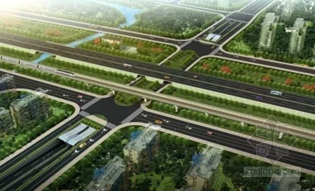
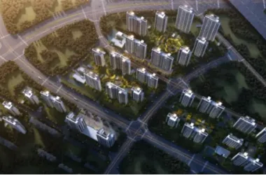
Figure 1: Aerial View of Chenxiang Road Tunnel
Project Overview
Chenxiang Road is a Class I urban secondary road featuring four lanes in each direction. Spanning approximately 500 meters from K3+170, it crosses Guiwu Road, Guyiyuan Road, Metro Line 11, Hujia Expressway, Ruilin Road, and Tonghu Road from west to east. The project encompasses multiple disciplines such as roads, bridges, buildings, landscaping, drainage, and transportation facilities, representing a typical municipal engineering case.
Project Challenges
Overall Coordination: The Chenxiang Road Tunnel Project involves more than ten specialties, including tunnels, tracks, bridges, roads, utilities, architecture, and landscaping, requiring extensive design and coordination efforts.
Engineering Environment: The underpass passes beneath the elevated section of Metro Line 11 and the Shanghai Jiaxing Expressway. The minimum distance between the underpass structure and the rail transit pier is only 2.7 meters, presenting harsh construction conditions. Strict risk controls are necessary to ensure the uninterrupted operation of both the rail transit and expressway.
Underground Engineering: The project involves significant challenges such as high-risk deep foundation pits and complex deformation control.
Typical BIM Applications in Chenxiang Road Underground Engineering
This project marks the first use of BIM technology in municipal engineering by the Shanghai Urban Construction Design and Research Institute. Extensive exploratory practices were conducted throughout the project, fully leveraging BIM from initial planning and design through construction documentation and on-site execution.
BIM Application in the Survey Stage
The engineering survey requires comprehensive spatial and attribute data of the project and its surroundings. Autodesk Revit was used to develop a detailed 3D geological model, enabling designers and constructors to clearly understand project relationships and environmental conditions such as soil layers, groundwater, pipelines, and surface features. This facilitates rapid assessment and effective management of geological challenges and pipeline crossings.
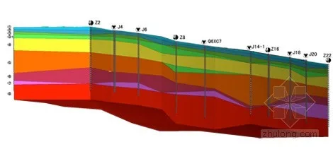
Figure 2: 3D Geological Model of Chenxiang Road Underpass
BIM Application in the Design Phase
The Chenxiang Road underpass involves multiple disciplines. Leveraging BIM’s parametric modeling capabilities, comprehensive BIM models were developed covering geology, the main tunnel structure, bridges, management buildings, drainage systems, pump stations, and the surrounding environment. Using Autodesk Navisworks’ clash detection feature, intelligent collision checks were performed. Conflicts identified in the reports were directly linked to the BIM model, enabling precise adjustments to components in the localized 3D models to prevent issues during design, fabrication, and construction.
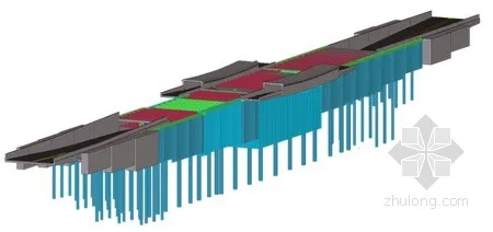
Figure 3: Enclosure and Structural Model of Chenxiang Road Tunnel
Autodesk Navisworks and Autodesk Infrastructure Modeler allow dynamic linking of BIM models to project schedules, offering an intuitive visualization of construction sequences.
Through a unified BIM design platform, close coordination with specialist design teams is maintained, and design results are shared at every stage. This approach minimizes errors and rework caused by communication gaps, significantly boosting design efficiency. BIM also supports mechanical, optical, and traffic simulations of underground structures, accelerating workflows and enhancing design quality.
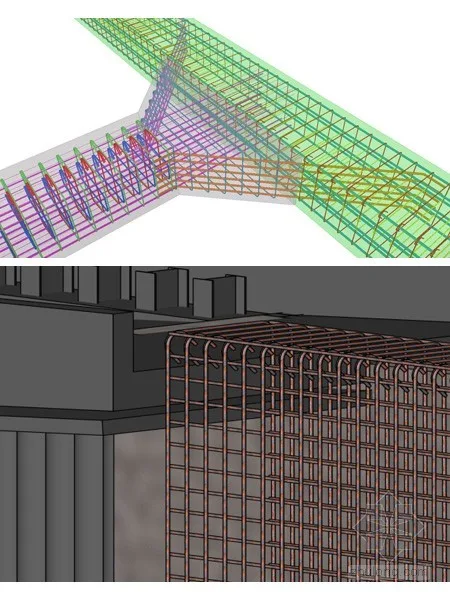
Figure 4: Reinforcement Model of Chenxiang Road Tunnel
In BIM-based tunnel structural calculations, seamless integration between Autodesk Revit and Autodesk Robot was achieved. BIM analysis results were validated against traditional finite element software, confirming that Autodesk Robot delivers reliable and effective engineering design calculations. This integration streamlines the process from modeling to design, saving time and effort, while greatly improving the efficiency of analyzing complex 3D structures.
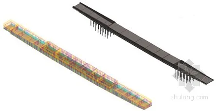
Figure 5: Structural Analysis Model of Chenxiang Road Tunnel
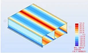
Figure 6: Cloud Diagram of Bending Moment for Buried Section Structure
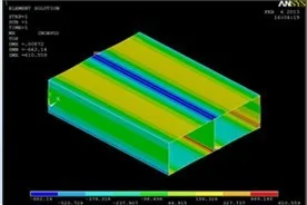
Figure 7: Comparison of Bending Moment Cloud Maps of Buried Section Structures
Additionally, BIM technology was used to conduct underground lighting analysis, transition section lighting evaluation, reflection pollution analysis from surrounding buildings, and traffic simulation. These analyses helped identify and mitigate potential safety hazards for drivers, underscoring the importance of sound design concepts for construction and operation.
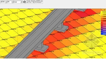
Figure 8: Daylighting Analysis Near Metro Line 11 for Chenxiang Road Underpass
While using BIM to generate architectural construction drawings is now common, its application in domestic municipal engineering projects remains less mature, particularly for structural drawings. In this project, a complete BIM model was used to produce construction drawings without relying on CAD platforms, meeting drawing requirements and significantly reducing errors.
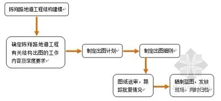
Figure 9: Overall Workflow of BIM Structural Drawing
Early in BIM structural drawing development, the Urban Construction Institute established a detailed approval process tailored to the project. The BIM main structure model was used to directly create 2D drawings and 3D renderings, including plans, elevations, and sections. This generated a complete set of structural construction design drawings featuring customized drawing frames, steel bar definitions, and dimension annotations. Drawings remain logically linked to the model, so any changes in the model automatically update associated graphics and annotations. From preliminary to construction design, only a single data file is required, eliminating redundant modifications and drastically reducing errors.
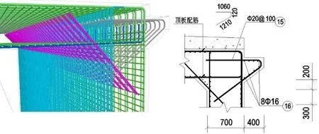
Figure 10: 3D Solid and Corresponding Sectional Detail of Reinforcement in Chenxiang Road Tunnel Project
BIM Application in Construction
During construction, the Urban Construction Institute pioneered using a robotic total station in municipal engineering. By directly importing the Autodesk Revit model into the measurement device’s notebook, on-site layout was streamlined, eliminating tedious coordinate calculations and complex computations. This approach improved efficiency and accuracy by 2 to 3 times.
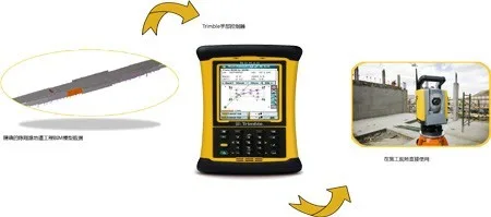
Figure 11: Automated Measurement Using BIM Model at Construction Site
In the Chenxiang Road underground project, 3D laser scanning technology was combined with BIM to perform extensive site surveys, information modeling, and management. This integration played a vital role during the survey phase and provided reliable data for design and construction.
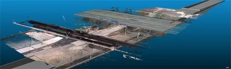
Figure 12: BIM-Based 3D Scanner Application
During construction, BIM models were dynamically linked to project schedules using Autodesk Navisworks and Infrastructure Modeler, offering a clear visualization of the construction process. Construction progress and site simulations were carried out, augmented by video production technologies to assist design and construction teams in integrating results and optimizing plans.
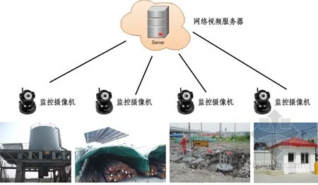
Figure 13: On-Site Monitoring Layout
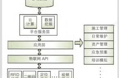
Safety features were incorporated into BIM models to simulate and demonstrate on-site protection measures, enhancing safety management quality. BIM plays an irreplaceable role in construction safety by modeling safety fences at hazard points such as openings, edges, and elevator shafts, enabling pre-construction safety briefings to optimize safe work plans. Combining BIM with monitoring technologies allows real-time supervision of lifting ropes, support shaft forces, and enclosure deformations. GPS-based positioning monitors personnel, materials, and equipment movement, ensuring efficient resource use. Portable devices like smartphones and tablets enable 3D BIM model viewing for site management, remote guidance, inspection, and documentation. These technologies collectively improve supervision, provide timely project insights, and track progress effectively.
Using Autodesk BIM software, comprehensive improvements were achieved across on-site conditions, scheme design, model analysis, construction simulation, and safety management. This significantly increased model reuse rates and reduced the overall cost of application research.
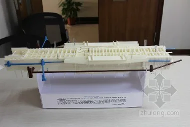
Figure 14: The First BIM-Based 3D Printed Model in Municipal Infrastructure Industry: Chenxiang Road Tunnel
During project decision-making and implementation, technical staff and management often hold differing perspectives. The 2012 completion of the Chenxiang Road underground model’s 3D printing—the first BIM-based 3D printed model in China’s municipal infrastructure sector—facilitated better communication between technical and non-technical personnel. This intuitive form of expression also improved interaction between project teams and owners.
Conclusion
The Chenxiang Road Tunnel Project, a general contracting engineering effort by the Shanghai Urban Construction Design and Research Institute, has demonstrated successful BIM applications across design modeling, drawing production, structural mechanics and performance analysis, traffic simulation, 3D printing, laser scanning, construction simulation, and robotic measurement. Leveraging the EPC project platform and the project’s characteristics, the institute fully utilized BIM technology throughout scheme initiation, preliminary design, construction drawings, and construction phases, significantly enhancing project efficiency and quality. Utilizing Autodesk’s BIM software suite, comprehensive advancements were achieved in on-site environment management, scheme design, model analysis, construction simulation, and safety management. These improvements increased model reuse, reduced application research costs, and delivered outstanding economic and social benefits for engineering construction.


Must log in before commenting!
Sign Up