
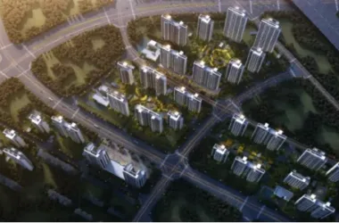
On October 26th, Building 28 within the central enterprise headquarters cluster in Zone B of the World Expo Park officially topped out. This site will feature a fully connected, super large underground “city” complex, while above ground, it will serve as a low-carbon, green, and ecological public activity center.
Following the World Expo, much attention has been given to land use within the park. Through comprehensive development, the Expo Axis has transformed into a large shopping mall. Zone B of the World Expo Park, located west of the “One Axis and Four Pavilions” layout, covers 18.72 hectares and already hosts 28 new buildings. It is set to become a business hub for central enterprise headquarters, including 15 major headquarters such as COMAC, Baosteel, State Grid, Huadian, Huaneng, CITIC, China National Building Materials, Aluminum Corporation of China, China Gold, China Merchants, Sinochem, Sinotrans, and China News.
The underground development in the central enterprise headquarters cluster is known as the “super underground project” closest to the Huangpu River. Excavation boundaries come within 10 meters of the completed Metro Line 13, with depths ranging from 11 to 20 meters—deeper than nearby subway stations at their lowest points. Ultimately, the underground spaces of these 28 buildings will be interconnected and linked to surrounding subway stations, the Expo Axis, Expo Exhibition Hall, Expo Hotel, China Pavilion, and other underground facilities via connecting channels.
The construction team has achieved significant resource savings by applying advanced technologies, materials, processes, equipment, and BIM technology throughout the project. Compared to planned consumption, actual electricity use dropped by 18.3%, diesel consumption decreased by nearly 10%, and water usage was reduced by over 5%.
The project lead from Shanghai Construction Engineering Group, responsible for general contracting, noted that by the end of the year, curtain walls and equipment installation for all 28 buildings will be substantially completed.
Application of BIM Technology in Ultra Large Underground Spaces
1. Introduction
With urbanization advancing, underground spaces are increasingly developed on a large scale, often in integrated and clustered formats. Notable examples such as Jinmao Tower, Zhengda Plaza, Global Financial Center, and Shanghai South Railway Station feature underground areas exceeding 50,000 square meters. Designing and constructing these underground spaces involves complex coordination among multiple units and remains a critical challenge in overall project management.
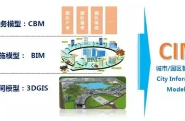
Building Information Modeling (BIM), introduced to China since 2002, has matured into a vital technology in construction. BIM’s value is especially evident in addressing challenges during underground space construction. The Expo Central Enterprise Headquarters Base in Shanghai, featuring approximately 450,000 square meters of underground space, serves as a key project applying BIM to overcome construction difficulties and pioneer innovations in underground space development.
2. BIM Application in the Underground Space of the Expo Central Enterprise Headquarters Base
2.1 Overview and Characteristics
Zone B of the World Expo exhibition and business district extends east to Zhoujiadu Road, Bocheng Road, and Expo Hall Road; south to Guozhan Road; west to Changqing North Road; and north to Expo Avenue.
The Expo Central Enterprise Headquarters Base in Zone B encompasses approximately 450,000 square meters of underground space. Its commercial corridors connect Zones A and C and integrate with Metro Line 13. Vertical transportation links connect to the Expo Hotel’s underground commercial area along Bocheng Road to the east, the China Pavilion directly, and Zone C via Line 13 to the west. This creates a core east-west pedestrian underground corridor within Expo Park, forming Shanghai CBD’s largest, most comprehensive, and efficient underground public space system.
The planning and development of Zone B’s underground spaces adhere to unified planning, comprehensive development, rational utilization, and legal management. Coordination aligns with Shanghai’s social, economic, and environmental growth, supporting the city’s urban development strategy.
Development and management of underground spaces in Zone B follow principles of “unified planning, design, construction, and management.”
Key characteristics of underground space construction in this headquarters base include:
- Numerous individual buildings with interconnected underground spaces, but above-ground buildings lack unified design, posing significant challenges for overall coordination, interface management, complex spatial arrangements, and functional layouts.
- The underground public space is constructed by the World Expo Development Group but is jointly funded and shared by multiple owners. Establishing scientific investment control, quantity calculation, and cost-sharing mechanisms is a major challenge.
2.2 BIM Technology Application Points
(1) Visual Design
BIM’s 3D modeling allows designers to move beyond traditional plan views, enabling real-time visualization and inspection of architectural spaces. Designers can revise complex pipeline layouts intuitively, viewing models from any angle, and generate section views automatically within Revit MEP, preserving details like specifications, elevation, and materials.
Electromechanical comprehensive drawings benefit greatly from simultaneous 2D and 3D views, producing accurate, visual results while reducing manual drawing tasks. This approach minimizes information loss common in 2D drawings and enhances understanding among designers, engineers, and construction teams, significantly boosting efficiency.
BIM not only provides 3D visualization but also facilitates improved communication and coordination among designers, owners, and end-users, breaking down technical barriers.
(2) Quantity Statistics
BIM transforms cost management into a collaborative enterprise-wide process. Cost data is stored in a BIM database, allowing multi-dimensional analysis, sharing, and controlled access based on user roles. This improves efficiency and safeguards core enterprise data.
Integrating BIM data with enterprise ERP systems enhances data reliability and convenience, reducing errors and manual input inefficiencies. This integration supports comprehensive resource and project management, lowering operational and project costs.
(3) Pipeline Integration
BIM’s 3D visualization enables early-stage collision detection, optimizing engineering designs to reduce errors, losses, and rework during construction. Optimized clearance and pipeline layouts minimize equipment conflicts and human errors prevalent in traditional 2D coordination.
(4) Virtual Construction and Effective Collaboration
By combining 3D visualization with time sequencing, BIM supports virtual construction simulations. This allows real-time comparison of planned versus actual progress, fostering collaboration among construction teams, supervisors, and stakeholders, including non-technical leadership. Integrating BIM with construction planning, simulations, and on-site monitoring reduces quality and safety issues, minimizing costly rework.
(5) Emergency Evacuation Simulation
Escape simulations model evacuation scenarios in large buildings using BIM data imported into specialized software. By setting evacuation capabilities for different user groups, various evacuation plans can be tested and optimized to identify the safest strategies.
In ultra-large underground projects, such simulations are crucial for disaster preparedness, enabling pre-disaster analysis, risk mitigation, and emergency response planning to enhance overall safety.
2.3 BIM Work Status and Progress
(1) Project Application Status
This project initiated a research program titled “Key Technologies for Digital Collaborative Management of Large Building Groups in Shanghai World Expo Central Enterprise Headquarters Base,” divided into five sub-projects focusing on BIM-based collaborative platforms, multi-design coordination, multi-construction coordination, multi-supervision management, and construction scheme optimization.
A BIM-focused research group led by the World Expo Development Group has begun work according to plan. While the project deadline is the end of 2015, interim results have been published. The project integrates research with practice to address real challenges and advance BIM applications.
(2) BIM Working Model
Ensuring unified planning and integration of underground and above-ground spaces is essential for regional functionality and future Expo projects. To manage BIM coordination across multiple participants, a unified collaborative organizational mechanism has been established.
3. Challenges in Underground Space Construction and BIM Solutions
The underground space development faced numerous technical challenges. BIM technology was leveraged to address these issues, although promoting BIM adoption was complex. The central enterprise headquarters remains committed to advancing BIM use in underground construction.
With over ten owners involved, disputes over pipeline routing and space allocation arose. The underground space includes multiple public continuous walls and support structures, complicating investment allocation. Issues with pipeline clearance and spatial constraints along underground roads were also significant. Since some owners lacked understanding of underground space principles and BIM’s value, the command center organized multiple BIM training sessions to build a comprehensive BIM model foundation.
3.1 BIM Quality Control and Integration Challenges
Multiple BIM design teams made it difficult to integrate models into a cohesive underground space model. A dedicated BIM consulting team was hired to review, integrate, and ensure model quality. This workflow supports centralized quality control and model management.
3.2 Pipeline Coordination Challenges
All pipelines originate from the Energy Center to 28 buildings. Two-dimensional drawings failed to adequately represent routing, clearance, and functional impacts on water supply, HVAC, electrical, and fire systems. Pipeline integration often reached deadlock with traditional methods.
After multiple coordination meetings, the Central Enterprise Command decided to use BIM models for pipeline integration, leveraging BIM to resolve conflicts and optimize layouts.
3.3 Multi-Party Coordination Challenges
With numerous design units and stakeholders, coordinating pipelines, clearance, civil defense zones, fire zones, and shared versus individual underground spaces was complex. Two-dimensional drawings proved abstract for owners unfamiliar with technical details, complicating communication.
BIM’s 3D visualization greatly improved communication clarity and efficiency, facilitating more effective coordination.
3.4 Investment Allocation Challenges
The integrated underground space features overlapping areas and public sections like continuous walls and enclosure structures. Investment allocation principles had to satisfy all owners’ requirements, posing challenges for project implementation.
BIM quantity statistics and parameterized project data were used to support investment supervision, demonstrating allocation principles transparently.
3.5 Construction Technology Challenges
Construction involved a super large foundation pit, with difficulties like managing underground passages near existing common ditches. Ensuring construction safety required selecting appropriate processes.
BIM coordinators organized collaborative design and construction planning sessions. Static BIM models were complemented by dynamic construction simulations, videos, and reports to support decision-making.
3.6 Additional BIM Applications
Beyond the discussed challenges, BIM has been explored for disaster escape simulation, quantity statistics, design optimization, and construction support.
4. Summary and Outlook
To date, an initial draft of the “BIM Technology Application Guide” has been completed to standardize BIM practices, with ongoing updates planned alongside project progress.
Promoting BIM in the underground space of central enterprise headquarters requires overcoming project complexities and stakeholder pressures. This project aims to expand BIM’s scope throughout the entire project lifecycle—from design and construction to operation—using BIM models at each stage.
BIM technology proves to be an effective tool for addressing underground construction challenges. Integrating BIM into project workflows enhances problem-solving and highlights BIM’s value and advantages.
This article shared insights into BIM applications at the Expo Central Enterprise Headquarters Base, inviting industry experts and scholars to engage in discussions and promote broader, deeper, and more valuable BIM development both within this project and across China.


Must log in before commenting!
Sign Up