1. Introduction
In the construction industry, Building Information Modeling (BIM) technology is rapidly advancing, heralding a revolutionary shift in information management. BIM uses comprehensive data related to construction projects to create detailed building models, digitally simulating real-world building information. Concurrently, China is actively developing digital cities. The National Bureau of Surveying, Mapping and Geoinformation has initiated the construction of digital city geographic spatial frameworks in 220 cities across 29 provinces, autonomous regions, and municipalities. Given the scale and complexity of digital city development, fully digitizing urban entities remains a significant challenge. However, BIM technology offers a promising solution by accelerating this digitization process and enhancing the accuracy and quality of urban models.
2. Digital City
A Digital City represents the primary direction for future urban development. It leverages advanced digital information processing and network communication technologies in urban planning, management, production, and daily life. The goal is to integrate and utilize diverse urban information resources effectively, maximizing the potential economic, social, and functional benefits of vast urban data. This integration improves the scientific, standardized, and democratic nature of government decisions, making urban planning more rational and timely while enhancing urban management precision. Ultimately, this fosters sustainable urban development and improves the quality of life for residents.
Constructing a Digital City is a highly complex and large-scale project. It requires foundational support from computer technology, multimedia, and large-scale data storage, connected via broadband networks. Technologies such as remote sensing, global positioning systems (GPS), geographic information systems (GIS), telemetry, and virtual simulation provide multi-resolution, multi-scale, multi-temporal, and multi-type three-dimensional urban descriptions. In essence, digital city construction involves digitizing and virtualizing all past, present, and future urban content through information technology.
The technical foundation of GIS includes the “3S” technologies—GPS, GIS, and remote sensing (RS)—along with networks, data warehouses, knowledge mining, scientific computing, visualization, and virtual simulation. GIS technology, crucial to Digital City development, has evolved from two-dimensional (2D) to three-dimensional (3D) models. Research on three-dimensional city models (3DCM) has become a hot topic, especially relevant in transportation, geology, mining, surveying, urban planning, construction, and environmental protection.
3. Three-Dimensional City Model
With the rapid growth of urban environments, expressing and processing three-dimensional information has become increasingly vital. Instead of focusing solely on individual buildings or small clusters, there is a growing need for comprehensive urban landscape models. These models support urban planning, traffic control, signal station placement, and other related tasks. Consequently, the volume of data to process expands dramatically—over 100 times more than traditional 2D GIS data. However, GIS technology currently lags behind CAD and 3D modeling software such as 3DMax in 3D data modeling and visualization capabilities. To address this, many researchers have combined these technologies to develop comprehensive 3D city landscape models, marking the beginning of 3DCM research.
4. Traditional 3D City Modeling Methods and Their Limitations
4.1 Traditional 3D City Modeling Methods
Creating a three-dimensional city model offers an intuitive and realistic representation of urban spatial information, allowing virtual exploration akin to on-site experiences. Different 3DCMs have been developed for various applications, categorized as follows:
(1) Remote Sensing Images Combined with Digital Elevation Models (DEM)
This method uses DEM to generate 3D terrain perspectives, mapping remote sensing images as textures onto terrain surfaces. While effective for terrain visualization, it lacks the ability to display 3D solid surface objects, perform spatial queries, or manage hierarchical data. Commercial GIS software like ArcView and MapGuide offer this terrain display functionality.
(2) Methods Based on 2D GIS Data
Using existing 2D GIS data and 3D attribute information, 3DCMs are constructed through:
① Adding height, wall textures, and other details to 2D GIS data to simulate 3D buildings. This approach results in models with limited realism and urban landscape expression, often ignoring DEM data.
② Combining DEM with 2D GIS, where DEM represents ground undulations and buildings are constructed using assumed heights and textures, enhancing realism compared to the first method.
Some 2D GIS systems (e.g., Arc/Info) have modules for 3DCM creation with basic measurement functions but lack effective texture extraction, reducing landscape realism.
(3) Pure 3D Construction Methods
Based on data collection approaches, pure 3D city modeling methods include:
① Ground-based photography and laser scanning, limited by visibility and challenging in dense urban areas.
② Satellite imagery and airborne laser scanning, which offer fast data collection but with lower DEM accuracy.
③ Aerial stereo image pairs combined with target extraction technologies, enabling semi-automatic 3D building data measurements and realistic texture restoration on visible building surfaces, effectively reconstructing urban landscapes.
4.2 Limitations of Traditional 3D City Modeling Methods
Traditional 3D city modeling faces several challenges:
(1) Large engineering scale: These methods require extensive human and material resources, resulting in significant workload and long project cycles.
(2) Trade-off between quality and efficiency: Enhancing model accuracy increases workload, while accelerating progress often compromises quality.
(3) Absence of building interior data: Traditional methods typically model only external structures, neglecting internal building information, which would demand even more resources if included.
5. Introduction to BIM Technology
BIM technology digitally models construction projects on computers, integrating not only 3D visualizations but also comprehensive building information useful throughout design, construction, and management phases. BIM markedly improves efficiency and reduces risks across the project lifecycle. It has been widely adopted in developed countries and is increasingly explored domestically.
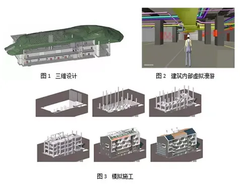
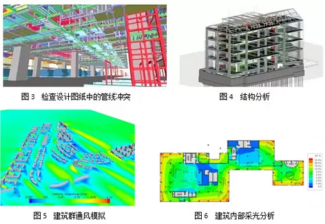
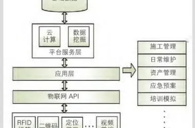
Figures 1–6 illustrate various BIM applications.
The National BIM Standard (NBIMS) in the United States defines BIM as:
① A digital representation of the physical and functional characteristics of a facility;
② A shared knowledge resource that supports reliable decision-making throughout the facility’s lifecycle—from construction to demolition;
③ A collaborative process where different stakeholders input, extract, update, and modify information according to their responsibilities at various project stages.
6. Advantages of Using BIM for 3D City Modeling
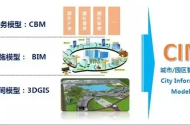
Integrating BIM technology into digital city 3D modeling simplifies model creation by focusing on BIM database development. BIM enables the construction of more accurate and detailed 3D models with several key benefits:
(1) Accessibility of BIM models: BIM models are increasingly replacing traditional architectural drawings, meaning new buildings must have BIM models guiding their construction. Governments can mandate BIM submissions for new structures, facilitating their integration into city-wide 3D models.
(2) Rich model information: BIM models encompass extensive data, including exterior and interior details, materials, and costs. This depth of information enhances user queries within 3D city models.
Feasibility of BIM and GIS Data Exchange
Combining BIM and 3D GIS technologies requires establishing standards for data exchange. BIM data can be imported into GIS to serve as a crucial source for digital city 3D models, while GIS data provides spatial context for building information models.
The Industry Foundation Class (IFC) standard, developed by the International Alliance for Interoperability (IAI), is widely accepted for BIM data standardization. IFC facilitates data sharing across different professions and software in construction. Converting IFC data to CityGML (a virtual 3D city model format) involves semantic and geographic information translation through three key steps:
① Defining a rule set for semantic class mapping between IFC and CityGML;
② Establishing rules or algorithms for simplifying geometric models, aided by BIM model views;
③ Determining attribute information for each Level of Detail (LOD) object to be converted into CityGML.
8. Conclusion
The integration of BIM data with three-dimensional city model data enhances model quality, expedites progress, reduces costs, and shortens project timelines.
Applying BIM technology to digital city 3D modeling represents a transformative advancement. It enables extensive data sharing and precise model construction, fostering seamless communication across disciplines and providing faster, more accurate support for digital city management.
References
Li Yongquan, Han Wenquan, Huang Zhizhou. “Comparison and Analysis of 3D Modeling Methods for Digital Cities.” Modern Surveying and Mapping, 2010(2).
Cui Liangqiang, Liu Chunfeng. “Key Technologies Analysis of 3D GIS for Digital Cities.” Surveying and Spatial Geographic Information, 2010(4).
Shao Lebin, Zhong Ershun, Liu Jiyuan, Song Guanfu. “Discussion on the Basic Problems of 3D GIS.” Chinese Journal of Image and Graphics, 2001(9).
Feng Yan, Guo Ronghuan, Wang Minqi, Gu Xingye. “Research on the Organization and Management Methods of 3D City Model Data.” Surveying Science, 2011(1).
Liang Zhenxing, Guo Chao, Guo Xin. “Exploring the Application of GIS Technology in the Construction of Digital Cities.” 2013(5).
Liu Cuiming. “Preliminary Exploration of 3D City Model CityGML.” Urban Survey, 2010(1).
Li Dechao, Zhang Ruizhi. “Research on the Application of BIM Technology in 3D Modeling of Digital Cities.” Civil and Architectural Engineering Information Technology, 2012(1).
Sun Min, Ma Ainai, Chen Jun. “Review of the Current Research Status of 3D City Models.” Journal of Remote Sensing, 2002(2).


Must log in before commenting!
Sign Up