1. Introduction
Traditional highway management—especially for expressways—involves routine operations such as maintenance, inspection, administration, rescue, and emergency response. These tasks require extensive information gathering from various management levels, maintenance teams, and on-site reports. Typically, managers must review design documents, statistical reports, drawings, and photographs to understand and analyze situations for decision-making. However, the overwhelming volume of data, its incompleteness, lack of accuracy, and retrieval difficulties make these conventional methods inefficient and challenging. Even when information is available, non-experts often find the data unengaging, graphics abstract, and information disconnected—hindering effective highway operations and maintenance. This problem intensifies during emergency response situations.
The challenge is evident across multiple highway networks. With the rapid expansion of China’s “7918” national expressway network, provinces now manage networks stretching hundreds or thousands of kilometers—some reaching 3,000–5,000 kilometers. As these networks grow, management complexity increases.
A promising solution is emerging through the application of real-scene 3D GIS, utilizing Mobile Mapping System (MMS) technology that integrates high-definition digital photography, gyroscopes, and GPS. This method has the potential to fundamentally change highway management.
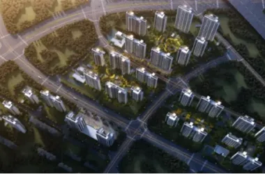
With an MMS-based real-time 3D GIS system, detailed data can be collected for every kilometer of road, each interchange, tunnel, bridge, toll station, service area, parking lot, slope, culvert, overpass, underpass, and any other relevant structure or equipment. All information is consolidated into a GIS database for the entire road network. Managers can visualize any asset under their control in real-time without leaving their desks. Questions regarding database scale, collection time, retrieval speed, and user concurrency will be explored in later sections using real-world data and case studies.
2. The Relationship Between GIS Technology and Highway Management
By the end of 2009, China had constructed approximately 65,000 kilometers of highways.
Highways are characterized by their extensive length, network structure, and wide coverage. Each province, region, or country possesses a vast network comprised of countless roads, bridges, tunnels, slopes, green areas, overpasses, toll stations, monitoring stations, substations, service areas, parking lots, and other infrastructure. Although these facilities are scattered and serve different functions, they are closely interconnected and interdependent. Persistent challenges such as congestion, accidents, and natural disasters can occur anywhere in the network, requiring comprehensive knowledge of the highway’s geographic context and the use of modern GIS technologies for effective management and emergency response.
Therefore, GIS systems have become an essential part of modern highway management.
2.1 The Inseparable Link Between GIS and Highway Management
What is GIS?
GIS, or Geographic Information System, is a system for managing location-based information.
Every object on Earth has a location that can be described using GIS coordinates. For highway networks, GIS coordinates are vital for accurate management of all facilities and structures.
Traditional highway management without GIS databases or coordinates provides statistical reports, drawings, and images, but lacks a clear, network-wide layout of all assets. As networks grow, understanding spatial and functional relationships becomes increasingly challenging.
Accurate geographic information is crucial for operations, maintenance, and emergency response. For example, knowing which sections have the highest traffic volume, greatest congestion, or highest maintenance costs—and understanding their spatial relationship to surrounding structures—requires GIS. In emergencies such as tunnel fires, GIS allows for immediate identification and deployment of the nearest firefighting resources, emergency teams, and evacuation routes. All these applications rely on a comprehensive GIS database.
2.2 The Evolution of GIS in Highway Management
GIS has been used in highway surveying, design, construction, and management for more than 15 years.
Due to the decentralized and expansive nature of highway networks, geographic information links different operational services, including toll collection, communication, monitoring, maintenance, and asset management. Integrating advanced technologies and improving management practices to create visualized and digital highway management systems is now urgent.
Globally, researchers have introduced GIS to highway information management with positive results in construction, enforcement, and asset management. For example, the US Federal Highway Administration uses GPS, GIS, and multimedia video for rapid asset assessment and safety assurance, while New Zealand’s ROMDAS system combines GPS and video for visual road management.
In China, however, multiple departments—operations, administration, maintenance—maintain independent information systems with incompatible formats, making unified geographic data integration and business data sharing difficult. This fragmentation limits collaboration and impedes comprehensive highway monitoring.
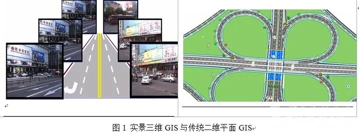
Earlier GIS implementations relied on 2D maps, which are inadequate for representing complex terrain—a major limitation in mountainous or narrow road areas. Two-dimensional maps struggle to convey spatial relationships between facilities, such as signs on a pole or billboards on a bridge, making interpretation difficult for non-experts.
Advances in computer simulation, 3D animation, and GIS technology have resulted in 3D simulation GIS, making GIS more accessible to non-specialists. However, creating 3D GIS databases remains expensive and time-consuming, limiting broader adoption.
Real-scene 3D GIS technology based on MMS now offers a breakthrough. Like the Windows operating system made computers accessible to everyone, real-scene 3D GIS allows business, management, and leadership personnel to analyze situations using intuitive real-time GIS video, instead of abstract data and images. Users can quickly assess the status of roads, structures, and traffic, and make informed decisions using real-time data.
Continuous development and deployment of real-time 3D GIS will make GIS technology more convenient and indispensable for highway management and many other industries.
3. Core Technologies of Real-Scene 3D GIS
Traditional GIS spatial analysis based on 2D maps is limited to high-level, broad analyses and cannot provide detailed environmental data needed for informed decision-making in highway management. This gap highlights the need for new data sources and management methods, which can be addressed by realistic 3D GIS technology and MMS-based mobile data collection systems.
3.1 Realistic 3D GIS
High-resolution aerial and satellite imagery provide a comprehensive bird’s-eye view, but traditional GIS users are limited to abstract 2D or simulated 3D maps at ground level, which do not fully represent real environments. Most industry GIS solutions remain based on symbolic 2D maps, offering only flat graphical displays. However, rapid advances in mapping, computing, and networking technologies are enabling real-time 3D GIS, which is now recognized as a key trend in international GIS applications.
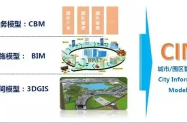
Realistic 3D GIS builds upon 2D GIS by incorporating continuous, realistic 3D imagery and integrating it with industry applications through open platforms like the TrueMap geographic data platform. This provides users with a vivid visualization environment rich in spatial and elevation information, supporting advanced management and decision-making. It essentially creates a “panoramic view” for even the largest highway networks.
Since 90% of highway management operations are location-based, geographic data is essential. Conventional systems rely on simple 2D vector maps, with facilities represented by flat symbols. This can be confusing when multiple signs share a single pole or when understanding the relative positions of features like signs, billboards, or cables. Real-time 3D GIS overcomes these limitations, providing richer spatial video information for highway management and maintenance.
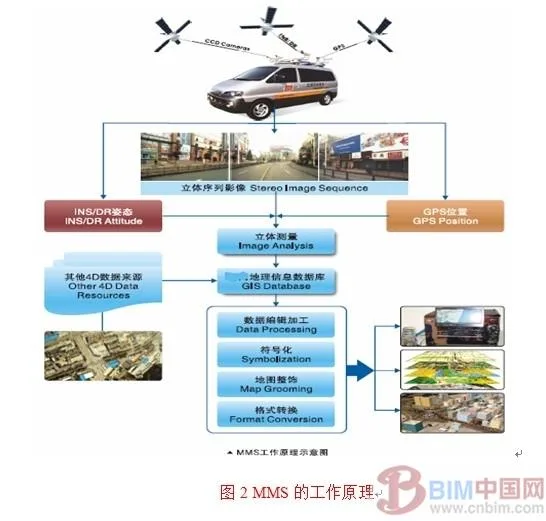
3.2 MMS Mobile Collection System
The mobile road information collection system equips vehicles with advanced sensors such as GPS, CCD cameras, and gyroscopes. As the vehicle travels at speeds of 80–100 km/h, it rapidly gathers spatial and attribute data for roadways and roadside features, storing this information onboard for later processing. After editing and processing, a comprehensive set of geographic data is produced. On average, about 100 trillion data points are collected and processed per kilometer, depending on the specifics of the information gathered.
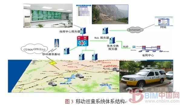
3.3 Mobile Inspection System
For ad-hoc and emergency information gathering, a mobile inspection system is deployed. Patrol vehicles equipped with GPS, video, stereo imaging, and 3G transmission devices quickly collect and transmit real-time video to the command center, enabling rapid response and decision-making in emergencies.
4. Applications of the 3D Realistic GIS Highway Comprehensive Management System
4.1 System Architecture for Comprehensive Highway Management
With the expansion of national highway projects like the “7918” plan, provinces and cities across China are building extensive highway networks. Regional highway management is now a critical priority at both provincial and national levels. The Ministry of Transport and provincial governments are establishing road network centers, where GIS platforms—especially those using real-scene 3D technology—play a central role.
A digital highway system based on real-time 3D GIS uses mobile measurement systems to capture visible, measurable, and analyzable ground-level images, integrating them with high-resolution remote sensing data. The resulting digital highway platform enables comprehensive database construction and visualization. Real-world images can be measured, annotated, and linked to professional databases, combining geographic, operational, and visual data. This platform supports highway planning, network layout, construction, disaster prediction and warning, emergency management, and enables digital, visual, and intelligent highway management.
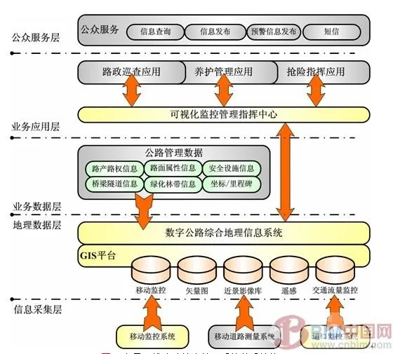
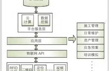
Figure 4: Architecture of Real 3D Highway Comprehensive Management System
The typical system is divided into several layers: information collection, geographic data, business data, business application, and public service.
The information collection layer uses mobile measurement systems, mobile monitoring systems, and intersection monitoring systems for multi-source data acquisition. The management system utilizes basic geographic data (2D vector, remote sensing, real 3D images) as well as real-time intersection and status data collected via mobile monitoring.
Data storage is organized into two layers: a geographic database with spatial and environmental data, and a business database with property, coordinate, and milestone information.
The business application and public service layers provide a real-time 3D visualization platform for industry decision-making (inspection, maintenance, emergency command), while the public service layer delivers travel, road, and public transport information to the public.
4.2 Highway Administration Management with Realistic 3D GIS
To ensure normal highway operations, inspection departments regularly evaluate road and facility conditions, update and analyze maintenance data (such as defect repairs and daily maintenance records), and support management and safe traffic flow.
A comprehensive management system based on real-scene 3D imagery establishes a monitoring network using vehicle, portable, and fixed systems, all based on GPS, GIS, and surveillance equipment, significantly improving road administration efficiency.
1) Portable system: Inspectors utilize handheld computers with electronic maps and GPS to inspect road sections and facilities directly. Data can be synchronized with the command center via mobile networks for rapid inspection and case processing.
2) Mobile Inspection Vehicle System: These vehicles transmit inspected road conditions, incidents, and locations to the command center via video and GPS. Stereoscopic images can be taken as needed for real-time evidence and law enforcement.
3) Fixed monitoring system: This system collects traffic flow and vehicle type data using coil sensors, and monitors incidents with high-resolution surveillance cameras.
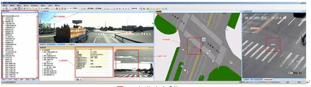
Figure 5: Visualization of Road Administration System
4.3 Highway Maintenance Management with Realistic 3D GIS
Maintenance is the core responsibility of highway management departments. The comprehensive system based on 3D real-world imagery provides complete support for maintenance by enabling real-time monitoring of road conditions via inspection vehicles and portable systems, achieving closed-loop management from defect detection to completion acceptance.
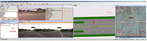
Figure 6: Visual Maintenance System Schematic
4.4 Highway Emergency Command with Realistic 3D GIS
Natural disasters and accidents—such as traffic collisions, tunnel fires, typhoons, floods, and snowstorms—can disrupt highway operations. To minimize losses and restore normalcy quickly, a robust emergency rescue and reserve system is essential. The comprehensive management system based on 3D real-time imagery offers crucial support:
1) The system provides aerial and ground-level 3D images, visualizing the spatial distribution and status of terrain, roads, materials, facilities, personnel, hazards, and risk sources across macro and micro perspectives. This interactive data enables faster and more effective emergency decision-making.
2) Mobile inspection vehicles can quickly reach incidents. Using wireless communication such as 3G, they transmit measurable images and video to the command center, enabling leaders to make informed decisions. Real-time imagery can also be used to assess damage, such as landslides or changes in traffic capacity.
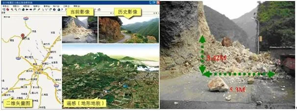
Figure 7: Emergency Command System
Imaging technology allows managers to monitor the locations and statuses of emergency agencies, facilities, hazards, and risk sources, and plan for contingencies. During emergencies, historical and real-time data can be compared for quick command. After disasters, this data supports damage assessment and reconstruction planning.
4.5 Public Travel Services Based on Realistic 3D GIS
Public transportation services, built on WebGIS, provide travelers with highway facility data, road conditions, navigation, and more. Using real images, videos, and 360-degree panoramas, these services are more engaging than traditional 2D maps. Core functions include publishing highway geographic information, facility data, and road conditions, personalized route selection, and real-time highway navigation. Typical subsystems include:
1) Travel Information Query: Enables travelers to access spatial and real-time road network information.
2) Path Selection: Users select departure and destination points, and the system dynamically generates routes based on current conditions, displaying them on an electronic map.
3) Realistic Navigation: Allows browsing of road images and navigation of landscapes and facilities (toll stations, service areas, parking lots, gas stations).
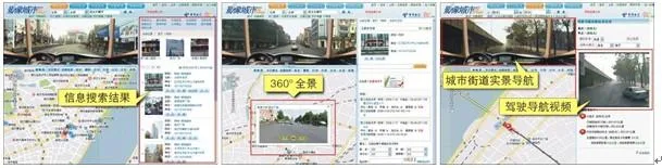
Figure 8: Public Service Based on Realistic 3D Images
5. Conclusion
Realistic 3D GIS represents the future of GIS applications, providing a robust foundation for highway information management. Mobile road surveying enables flexible, rapid, efficient, and accurate data collection and updating, supporting continuous improvement of digital highway databases. Mobile inspection systems, utilizing close-range photogrammetry and wireless communication, offer convenient business data collection for highway management. Together, these technologies empower comprehensive road administration, maintenance, inspection, and travel services—achieving full-process visualization, safety assurance, emergency response, and ultimately, digital highway management. This lays the groundwork for the “Digital Highway.”
References
__AI_T_SC_0_ Liu Weining, Sun Dihua, Song Wei, et al. Research on the Virtual Shared Information Platform for Intelligent Transportation. Journal of Chinese Highway Engineering, 2004, 17(4): 79-84
__AI_T_SC_0_ Zhao Zhonghua, Zhao Liming, Zheng Jiangbo. Highway Management Information System Based on Geographic Information System. Journal of Chang’an University: Natural Science Edition, 2005, 25(1): 69-72
__AI_T_SC_0_ Zhang Yingxue, Huang Limang. Research on the Application of GIS Technology in Highway Construction Management. Journal of Chinese Highway Engineering, 2004, 17(1): 90-93
[4] Wu, J. and Tsai, Y. (2006), Enhanced Roadway Inventory Using 2-D Sign Video Image Recognition Algorithm, Journal of Computer-Aided Civil and Infrastructure Engineering, pp. 369-382.
[5] Christopher Bennett, Experiences With Kinematic GPS Surveys in Developing Countries, Road Centerline Extraction and Maintenance Conference, 2001, Santa Barbara, CA, USA


Must log in before commenting!
Sign Up