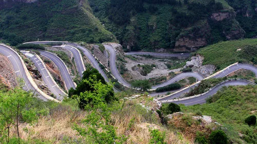
With the emergence of concepts like “beautiful countryside” and “harmonious society,” highway design must go beyond traditional concerns such as cost-efficiency, safety, comfort, and durability. Specifically, in mountainous road construction, the focus should shift towards creating “beautiful highways” and “harmonious highways.” Surveying and designing mountainous roads are critical components in this process, where scientific and rational planning greatly influences the overall construction outcome. Traditional 2D design methods are prone to oversights and insufficient considerations. In contrast, adopting BIM technology helps simulate the project in advance, preventing avoidable issues, and saving both time and costs.
BIM (Building Information Modeling) integrates engineering information related to construction into a 3D digital model that builds upon CAD technology. This innovation not only boosts designers’ efficiency but also transforms design thinking and workflows. BIM supports the entire lifecycle of a project—covering design, construction, operation, management, and maintenance. Although BIM has become increasingly popular in China’s mechanical and construction sectors, its application in mountainous road projects remains relatively limited due to unique challenges.
Application of BIM in Mountain Highway Design
The use of BIM in mountainous highway design can be categorized into three main phases: planning, surveying, and design.
Planning phase: BIM helps shorten design cycles during planning and enhances project performance by allowing assumption-based optimization.
Survey stage: BIM streamlines survey tasks and reduces time requirements. It allows all survey activities—such as raw geological data collection, least squares calculations, and data editing—to be performed within a unified environment. Additionally, terrain creation is interactive, minimizing hidden issues, and enabling automatic generation of points or surfaces directly usable in the project. Surfaces serve as references to produce objects dynamically linked to original data, with flexible selection of surface production models.
Design phase: Building road models with BIM enables detailed design of mountainous highways, including dynamic diagrams of planar intersections. BIM’s internal plugins assist in rapidly designing circular road networks, incorporating elements like sidewalks, lanes, lane combinations, side ditches, road signs, and traffic signals. The intuitive modeling environment also facilitates easier modification of road cross-sections and overall design optimization.
Application of BIM in Mountain Highway Construction
2.1 Roadbed Progress Model
Leveraging the BIM database and core modeling principles, combined with GIS data analysis, a visual 3D terrain platform is created based on the mountainous highway construction database. This platform links GIS databases with 3D terrain maps, enabling dynamic system functionalities.
2.2 Road Surface Progress Model
The pavement structure of mountainous roads consists mainly of a cushion layer, sub-base layer, base layer, and surface layer. The cushion layer prevents pollution, freezing, water infiltration, and facilitates drainage; the subgrade provides secondary load-bearing support; the base layer handles the main load; and the surface layer resists wear and sliding, as it directly interfaces with traffic loads. The road surface progress model links with the 3D topographic map to enable dynamic updates of the pavement structure.
2.3 Engineering Quantity Analysis
Earthwork is a critical aspect of mountainous highway projects. Common earthwork volume calculation methods include grid, sectional, and graphic techniques. However, these traditional approaches are labor-intensive, have limited accuracy, and require substantial effort. Therefore, accurate and efficient earthwork quantity calculation is essential.
Using BIM digital models, bottom and top grid models are created. The absolute difference between these surfaces represents the height for integration, while the unit grid area serves as the integration unit. Summing the calculated volumes across all grids yields the total earthwork quantity.
Challenges in Implementing BIM for Mountainous Highways
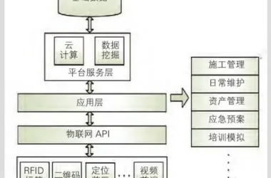
Mountainous highway design presents complex mechanical and architectural challenges. Unlike more standardized mechanical and architectural designs that concentrate within specific environments, mountainous roads can extend tens or even hundreds of kilometers and involve diverse elements such as tunnels, roadbeds, and intersections. These factors create a highly complex environment with low standardization. Thus, a key challenge is integrating numerous influencing factors effectively within BIM. The system required for mountainous highways must address multiple stages—from investment to construction, management, and maintenance—making it inherently complex.
To address these challenges:
(1) Current BIM software does not fully meet the needs of mountainous road design. Therefore, an open software platform should be developed, allowing municipal designers to perform secondary development tailored to their specific requirements and integrate existing software solutions.
(2) Mountainous highway design is governed by numerous standards, specifications, and legal requirements. Design results at each stage must comply with corresponding achievement standards. Government promotion is critical to deepen BIM adoption within mountainous highway and broader highway industries, bridging the gap toward advanced practices.
(3) BIM represents the future of design development. Despite relatively lower efficiency during initial adoption phases, commitment to BIM is essential. This approach gradually improves acceptance among stakeholders while accumulating valuable experience and talent.
(4) Comprehensive security measures must be embedded within BIM systems. User access should be managed at multiple levels to enhance security and confidentiality awareness.
4. Conclusion
Implementing BIM in project design offers clearer and more accurate project insights. Visualizing solutions and simulating construction processes help promptly identify problems and prevent unnecessary errors. Currently, the application of BIM in mountainous highway design is minimal, with a pressing need for related standards and software development. Advancing BIM adoption will improve productivity, reduce costs, and align with the rapid evolution of information technology.
References
__AI_T_SC_0_ Tsinghua University BIM Research Group, Internet Cube (isBIM) Company BIM Research Group Guidelines for BIM Implementation Standards for Design Enterprises __AI_S_SC_1_. Beijing: China Architecture & Building Press
__AI_T_SC_0_ Dong Jianfeng, Liang Xiao. Development of Informationization in Japan’s Survey and Design Industry Based on Data Collaboration. Civil and Architectural Engineering Information Technology, 2010 (3): 106
__AI_T_SC_0_ Li Zhiwu, Bai Xueyan, Xu Ming. Application of New Highway Design Concepts in the Survey and Design of Haotong Expressway. Silicon Valley, 2014 (4): 107-108
__AI_T_SC_0_ Guo Hongjiang. A Brief Discussion on the Application of BIM in Highway Design. Heilongjiang Transportation Technology, 2011 (9): 55-56
__AI_T_SC_0_ Lu Yang. Outlook on the Application of BIM Technology in Highway Design. Shandong Transportation Science and Technology, 2015 (5): 102-103
__AI_T_SC_0_ Li Li, Ma Tingting, Yuan Zhu. The Application of BIM Technology in Railway Tunnel Design. Railway Technology Innovation, 2014 (5): 89-91


Must log in before commenting!
Sign Up