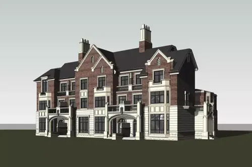
Four-row BIM model
In 1975, Professor Charles Eastman from Georgia Institute of Technology introduced the concept of Building Information Modeling (BIM). This approach uses diverse data related to construction projects as a foundation to create detailed building models. By simulating real-world building information digitally, BIM helps designers work more comprehensively and intuitively throughout the project lifecycle.
BIM is characterized by five key features: visualization, coordination, simulation, optimization, and graphing. These capabilities have made it one of the fastest-growing technologies in the construction sector. Over time, BIM has evolved and is now applied across various phases of construction, operation, and maintenance, far beyond just architectural design.
Since 2008, Huayang International has embraced BIM technology, progressively implementing it in public building and residential projects. Their BIM applications have ranged from Futian Science and Technology Square to Guangming New District’s Gongming Culture, Art and Sports Center, Liantang Port, and the Shenzhen Affordable Housing Standardization Series Research Project. In the northern district of Jingji Tianyi Jincheng Residential Community, Huayang International adopted a fully professional BIM design approach, utilizing BIM’s green analysis features to create a more ecological and human-centered community.
The project site is located at the intersection of Jingang Highway and Jinjin Expressway in Jinnan District. It covers roughly 1800 acres—766 acres dedicated to real estate development and over 1000 acres reserved for golf courses. The overall plan envisions a comprehensive, high-end community that combines commercial spaces, residential units, schools, and kindergartens. Huayang International was responsible for the high-end villa segment, designed in a European style that complements the surrounding golf course environment.
At the project’s outset, Huayang and the developer agreed to emphasize the community’s unique characteristics, adapt to local conditions, and fully leverage the natural landscape to enhance the leisure atmosphere. The design philosophy centers on a “people-oriented” approach, aiming to create a comfortable and culturally enriching environment. The plan includes 108 villas; despite a low plot ratio, the building density is relatively high. The challenge was to optimize the use of landscape and climate resources in this dense setting, minimize costs, meet functional needs, and ensure residents feel healthy and comfortable.
From the proposal phase onward, the developer maintained a cautious stance over four years, carefully reviewing the design but without reaching a satisfactory outcome. Li Yanbin, Vice President and Director of the Building Information Office at Huayang’s Shenzhen branch, noted that the client proposed many changes early on, especially concerning exterior façades and styles. Traditional 2D design methods made it difficult to visualize effects and implement adjustments. In this context, BIM proved indispensable by enabling multidisciplinary collaboration—architecture, structure, MEP, and others—while virtualizing results to significantly enhance work efficiency.
Huayang’s design team tackled the project from both planning and individual design perspectives, leveraging mature BIM technology within the company. Their efforts resulted in a high-quality, eco-friendly, and human-centric residential community.
1. Overall Planning and Design: Tailored to Local Conditions and Environmentally Friendly
1. Building Orientation
Tianjin experiences cold winters and hot summers, so building orientation needed to maximize winter sunlight while minimizing summer heat, as well as support natural ventilation. Using Autodesk Ecotect for climate analysis, the team determined that an orientation of approximately 10 degrees south by west was optimal. After considering landscape, land use, and architectural factors, the final building orientation was set to 15 degrees south by west.
2. Wind Environment in the Community
During early planning, the BIM platform was used to analyze and optimize the community’s wind environment. This improved airflow around buildings, creating comfortable outdoor spaces. Efficient use of natural ventilation is crucial for enhancing both the ecological quality and energy efficiency of residential areas.
In Tianjin’s hot summers, the dominant southeast wind averages 2.6 m/s. To reduce the heat island effect and energy consumption, the project prioritized introducing natural ventilation by lowering building density on the southeast side. Accurate calculations helped establish a building density that balanced technical requirements with airflow penetration.
In winter, when cold north and northwest winds prevail with an average speed of 2.9 m/s, the planning avoided facing buildings directly into these winds to minimize heat loss. Increasing building density in the northwest helped shield the community from cold drafts. Analysis showed that arranging buildings in staggered or angled layouts further reduced wind impact, resulting in a “sparse south, dense north” layout that supports ecological energy conservation by leveraging natural wind and site orientation.
3. Landscape Visibility
The community consists of 2- to 3-story villas whose views can obstruct each other. To ensure good visibility across the community, Autodesk Ecotect was used to analyze sightlines and identify areas with significant obstruction. Targeted adjustments were made to optimize the layout, seamlessly integrating buildings with outdoor views and ensuring landscape harmony for all villas.
4. Solar Radiation Analysis
Solar radiation analysis guided landscape design and enhanced community quality. The project team used Autodesk Project Vasari’s solar radiation tools to model the entire site. Deciduous trees were planted in high-radiation areas to provide summer shade, while allowing sunlight through in winter when leaves fall, creating warm spaces for residents. This BIM-based green analysis supports the creation of more ecological and human-friendly landscapes.
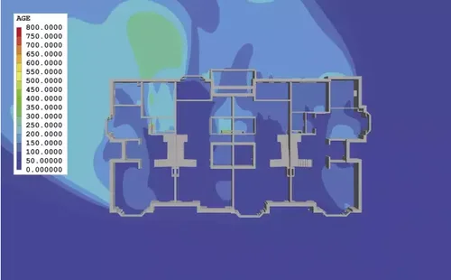
Four-row, first floor, southeast wind airflow analysis
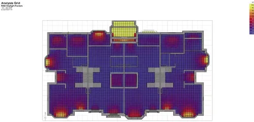
First-floor lighting rate analysis of four rows


Must log in before commenting!
Sign Up