1. Technical Background
Railway engineering is a complex and multidisciplinary field, encompassing five key elements: machinery, vehicles, engineering, electrical systems, and rolling stock. It covers aspects such as geography and geology, locomotives and rolling stock, electrical engineering, communications, signaling, tunnels, bridges, and maintenance. The development and enforcement of standards are crucial to the successful application of Building Information Modeling (BIM) in engineering. However, there is currently no BIM standard tailored specifically for railways within the existing BIM standards framework.
A unique challenge in railway engineering is that construction typically follows mountainous terrain and crosses bodies of water. Unlike typical construction sites, railway route engineering spans vast areas where geographical and geological conditions significantly influence project execution. One of the primary technical challenges for BIM in railway applications is integrating with Geographic Information Systems (GIS).
The advancement of specialized BIM software is vital to support BIM applications effectively. Presently, such software mainly caters to architecture and equipment-related fields, leaving many railway engineering disciplines without dedicated BIM tools. Additionally, dominant software vendors often lack open standards support and show limited commitment to developing railway-specific BIM software.
In summary, the three main obstacles hindering BIM development in the railway sector are: the absence of tailored standards, insufficient software support, and technological limitations.
2. Project Overview
The Chengdu-Kunming Railway reconstruction project, undertaken by China Railway 12th Bureau, includes the Tuo’an Tunnel section between Dashucun Station and Dianwei Station. The tunnel extends from mileage DK739+279 to DK752+650, spanning 13,371 meters. It is a double-track tunnel with track spacing ranging from 4.20 to 5.04 meters. The longitudinal slope features an 11.9% uphill grade over 25,829 meters, followed by 10% over 791 meters, and 1% over 1,460 meters. Except for two curved sections—the tunnel entrance (249.74 meters, left line) and tunnel body (1,707.69 meters, left line), both with a curve radius of 4,000 meters—the rest of the tunnel is straight.
The tunnel’s maximum burial depth reaches approximately 550 meters, with a minimum depth of about 20 meters. The segment between DK752+000 and DK752+100 crosses villages, where the minimum burial depth is around 35 meters. To accommodate construction needs, ventilation, disaster prevention, rescue operations, and waste disposal, the tunnel is equipped with three inclined shafts measuring 1,150 meters, 998 meters, and 1,477 meters horizontally. The first two shafts use single-track rail transport, while the third employs double-lane trackless transportation.
Currently, the project is in the construction phase and aims to implement 3D BIM technology throughout. This will enable thorough preparation during construction, enhance construction techniques, minimize design errors and omissions, and facilitate the visualization of construction plans not captured in design drawings. Simulations of construction processes, organization, and coordination based on the 3D BIM model will be used to optimize construction schedules and workflow.
3. On-site Organization and Management Using BIM Technology
Tunnel construction presents numerous challenges: complex geology, harsh environments, multiple processes, and continuous operations. These factors demand rigorous on-site organization and management. The foundation rock and soil conditions, along with hydrogeological factors, present inherent safety risks. Limited survey data, incomplete calculation methodologies, and unforeseen events during construction further increase these risks. Additionally, imperfect construction technologies, techniques, methods, and inconsistent adherence to regulations by personnel can impact safety. Therefore, effective organization and management are essential to ensure safe and civilized construction practices.
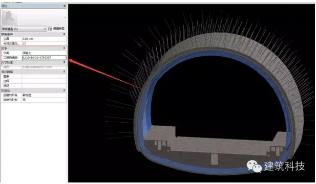
3.1 Information Integration
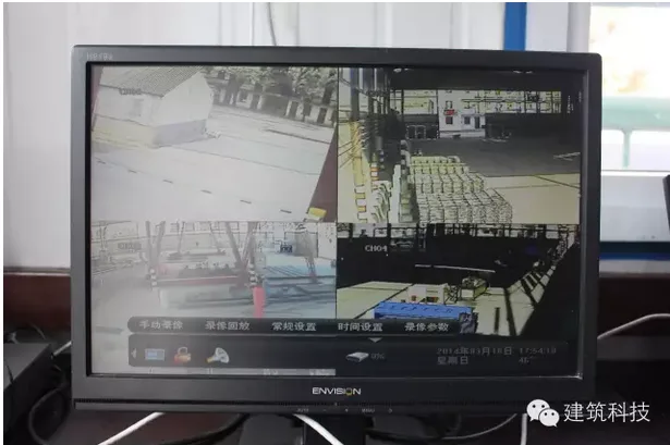
On-site data is linked with the BIM system to visualize information effectively. BIM serves as a platform for organizing and managing construction activities.
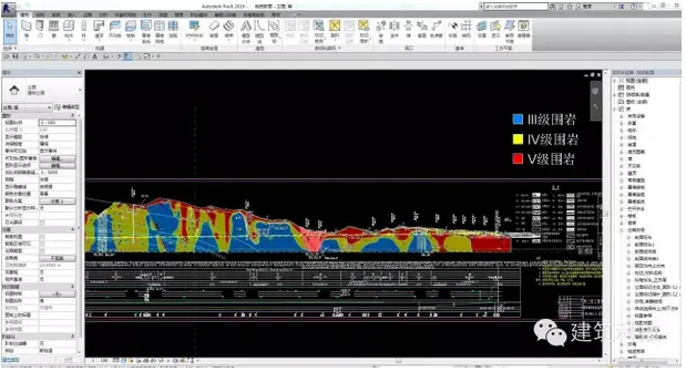
BIM integrates real-time monitoring systems to generate geological models for different tunnel segments. Various colors represent the classification of surrounding rock grades.
3.2 Site Planning
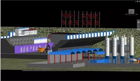
BIM visualization is used to strategically plan material storage and processing areas, ensuring efficient site layout.
3.3 On-site Tracking
Components are tagged with coding information. QR code technology, combined with monitoring systems, tracks materials and construction progress on-site, enhancing management accuracy.
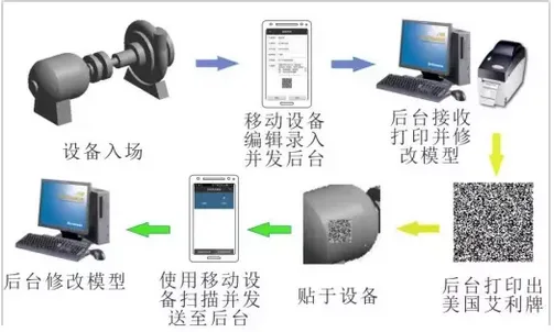
Encoding information is added to corresponding model components.
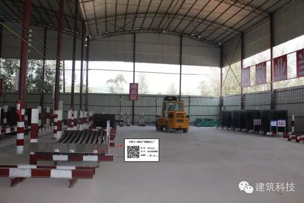
On-site structural components are identified and tracked using QR codes for recording and management purposes.
4. BIM Model Applications
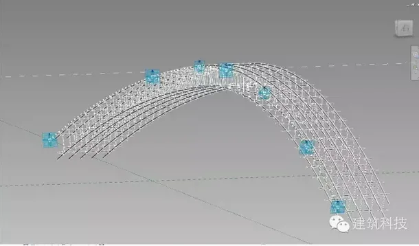
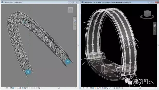
4.1 BIM Parametric Modeling
Adaptive modeling techniques are employed to create highly flexible models, improving efficiency and allowing for easy adjustments.
4.2 Model Output
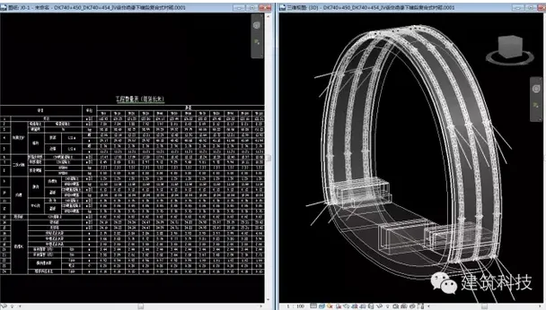
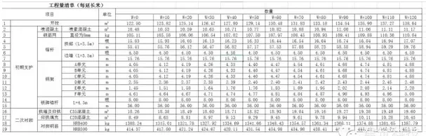
The model generates quantity lists based on design drawings.
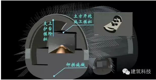
4.3 Process Simulation
BIM is used to visualize and simulate the construction process, providing clear guidance to workers and improving overall coordination.
Author: Wang Kewei, Zhuzheng Construction


Must log in before commenting!
Sign Up