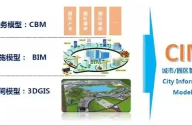
A city has planned a comprehensive urban rail transit network comprising four express lines: two horizontal and two vertical routes. The layout aligns with the city’s development axis, covering an overall scale of approximately 460 kilometers. One specific line is the first to be constructed, and during its construction, BIM + GIS technology will be introduced to transform traditional planning, design, construction, and operation processes for rail transit projects.
Project Objectives and Positioning
The main objective is to explore the development of rail transit projects using information-driven approaches, particularly on a designated line where BIM + GIS technologies have been applied and valuable experience has been gained. The project’s short-term and long-term goals are as follows:
Ø Provide comprehensive BIM+GIS consulting and technical services for the designated rail transit line.
Ø Build a smart rail construction and operation management cloud platform.
Ø Establish a data center for rail engineering in the city’s development zone.
Ø Conduct in-depth research on intelligent construction methods for the chosen line.
Ø Promote timely adoption of these approaches in other railway lines or national rail transit projects.
Construction Principles
The construction is guided by the management tasks of the specific line and aims for long-term safe operation. The principles include:
(1) Enhance capabilities and efficiency: Strengthen information management at the supercomputing center, improve BIM, GIS, cloud platforms, collaborative work platforms, and related data management and standard construction.
(2) Clear division of responsibilities and phased implementation: Break down planning objectives into stages, implement construction goals through comprehensive planning and distributed execution.
(3) Resource integration and avoidance of redundancy: Use research results to support planning, construction, and operation, integrate with existing systems, and avoid duplicate efforts.
(4) Adapt to current conditions and focus on long-term development: Meet present construction and operation needs, accumulate BIM+GIS experience, and provide support for other city lines and nationwide projects.
Overall Framework and Functional Analysis
Based on current information, the system will adopt a simple framework structure in the future.
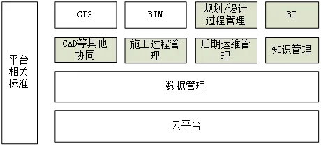
The system comprises the 11 modules shown above, with an emphasis on the BIM+GIS system.
Data Standards and Content
Data standards are crucial for system operation and should be properly defined at this stage. They cover a wide range of areas, including BIM mapping, coordination, delivery, management data, technical data, archive storage, and GIS storage standards. All these require regulation through data standards.
Extensive research into data standards is necessary to meet future operational needs. During this phase, key data standards and content should be established based on initial requirements analysis. This involves creating design, construction, operation and maintenance standards, as well as interface standards and coding rules.
For example, CAD design standards need to specify layers, fonts, printing styles, and borders to ensure uniformity in design drawings across all parties.
Establish Technical and Management Standards for BIM
Technical standards include:
1) LOD for model precision;
2) Model information standards;
3) Modeling standards;
4) Software standards.
Management standards focus on:
1) Allocation of BIM application rights and responsibilities (what information each participant needs and how to access it);
2) BIM management processes (what information is provided, how it is provided, and how participants collaborate on the BIM platform);
3) BIM bidding document support.
Due to immature compatibility of BIM software at different stages, in-depth exploration and secondary development are required to maximize data reuse, reduce costs, and enhance efficiency.
Platform standard content is extensive; only some typical aspects are listed here.
Construction of Basic Cloud Platform
The core value of BIM lies in effective use and expression of information. The cloud platform is designed around the value of customer data, integrating 3D virtualization, cloud system acceleration, high-performance parallel storage, IPS+firewall data security, data backup, and a cloud intelligent operation and maintenance platform. This ensures efficient data transmission and protection throughout the workflow, enhancing engineering practice.
3D virtualization cloud platform: Built with HPC servers, NVIDIA high-performance graphics cards, and SSD disk array acceleration cards. With 3D cloud systems, BIM software can be efficiently deployed in cloud environments, boosting efficiency and lowering costs, while preventing data leakage. The VIN2000 system offers a complete solution for BIM+GIS cloud platforms.
Cloud system acceleration: Network latency is the biggest challenge for cloud-based workflows. VIN2000’s cloud acceleration solution significantly speeds up data transmission from the platform to customer desktops, overcoming network delays.
High-performance storage architecture: Utilizes the V8000 parallel cluster storage architecture for effective data exchange. Benefits include:
Ø High-speed concurrent user access, ideal for collaborative design, construction, and review, especially for BIM model storage and GIS applications.
Ø Network-based load balancing to prevent data access bottlenecks.
Ø Multi-node architecture for reliability and continuity.
Ø Linear scalability to expand servers and storage as needed.
Ø Universal data protocol interface for backend support (PLM/PDM) for industry software like Autodesk and Cartia.
Ø Supports rapid deployment of virtual machines, improving efficiency and reducing costs.
Ø Excellent capacity for large-scale data protection throughout its lifecycle.
Data security: Collaborative user environments can introduce risks such as viruses or malicious code. The VeriCloud strategy employs IPS+Firewall, avoiding the limitations of single firewalls or antivirus, effectively safeguarding data and preventing unauthorized access.
Data backup: As the final safeguard for lifecycle data and supporting offline analysis, a robust backup mechanism is vital. The V8000 storage server is fully compatible with Symantec NBU’s backup engine and asynchronous cloud backup interface. Data can be securely backed up, enabling offline analysis and platform maintenance. Built-in deduplication saves over 70% of backup space.
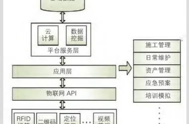
Cloud intelligent operation and maintenance platform: As a public resource platform, the subway collects vast real-time data. Creating an integrated intelligent management platform is essential. VeriCloud and NVIDIA have developed a centralized platform based on MOSIC technology, integrating BIM Technology and GIS. This platform facilitates data collection, display, and control across the subway line. A research group aims to establish a world-class subway cloud intelligent operation and maintenance platform through engineering practice.
BIM Application
The application of Building Information Modeling (BIM) in this project focuses on generating BIM big data across survey, design, construction, production, and operation phases, and utilizing this data for analysis and decision-making.
BIM applications include:
1. Survey stage:
Ø BIM data generation for terrain, pipelines, and surrounding buildings.
Ø Use of BIM data in surveying.
2. Design phase:
Ø Comprehensive BIM model creation, collision detection, and error correction.
Ø Advanced BIM pipeline design.
Ø BIM performance analysis.
Ø Quantity surveying.
3. Construction phase:
Ø Simulation of construction progress and processes.
Ø BIM model adjustments during construction.
Ø Quantity surveying.
Ø As-built model creation.
4. Operation phase:
Ø BIM model data entry.
Ø BIM model maintenance.
GIS Platform Application
GIS serves as the integration engine for the entire line, supporting the following functional modules:
1. Basic geographic information management: Using a local coordinate system, manage aerial images, terrain, cadastral data, and infrastructure status along the route within a unified map.
2. Underground pipeline management: Surveyed comprehensive pipeline data is unified on the GIS platform, supporting advanced 2D/3D visualization, queries, and section diagram generation to aid track design and construction.
3. Track line planning and design management: Manage station and section directions, elevations, and other planning elements on a unified map. Establish a data engine for spatial planning elements, supporting integration with BIM and version management.
4. Comprehensive development planning for properties along the route: Properties and land closely related to the line are managed on a unified map, enabling convenience in queries, statistics, and comprehensive services.
5. Associated project management: Manage project plans, progress, resources, and provide automated reporting based on the geographic database.
6. CAD-GIS-BIM linkage: Spatial element indexing enables database linkage between GIS and BIM, supporting multi-directional data connections (GIS2BIM, BIM2GIS, CAD2GIS) and ensuring real-time data consistency.
7. GIS-based completion drawing management: Real-time recording of plan changes and construction completion, establishing a comprehensive GIS database of track facilities and foundation for smart asset management.
These modules are deployed using cloud GIS technology and developed with B/S + mobile app/S architecture, enabling efficient integration of 2D and 3D GIS, high-performance computing, and networked data transmission. As 3D GIS in China currently uses only C/S architecture, this project demonstrates pioneering capability.
Basic Service Requirements for GIS Platform
1. Develop GIS data standards for integrated track planning, design, construction, and operation.
2. Plan, design, and select technical standards for the intelligent rail GIS platform.
3. Basic data processing: Standardize inclusion of data from various sources (current status, planning, schemes, completion drawings, etc.), types, formats, and coordinate systems.
4. Software customization and packaging: Develop personalized functions in addition to existing product features.
5. Provide training, operation, and maintenance technical support.
Operation and Maintenance Plan
Concept and Implementation of Cloud Intelligent Operation and Maintenance Management Platform: To effectively integrate BIM technology, GIS, and all project data on a unified platform for centralized display and management.
By building a centralized management platform, investment in BIM and IoT R&D is required to unify various data sources. The platform can display information across 32 large seamless screens and backend systems, consolidating video surveillance, real-time analysis, equipment management, risk warning, disaster prevention, and rescue into a single control center. This achieves efficient processing, intuitive management, and simplified workflows.
The recommended approach is: “Comprehensive planning, step-by-step implementation; gradual advancement of the plan.”
Summary
Implementing BIM+GIS-based management for a specific line is a large-scale project involving multiple domains. Only the most critical issues are outlined here, particularly data standards, cloud platform construction, BIM and GIS integration, and collaborative platforms. The system is currently going live, with further research to follow on its effectiveness and improvements.
Author Bio: Dr. Yang Guohua, Senior Engineer, and Senior Director of Collaborative Design at Sidi International


Must log in before commenting!
Sign Up