
Attached are the BIM design notes and process records for the overall site layout of Chucheng Manor.
1. Is the vertical site plan integrated with the overall fire protection plan into a single drawing? Previously, these were communicated as separate drawings. Currently, the overall plan does not reflect this integration.
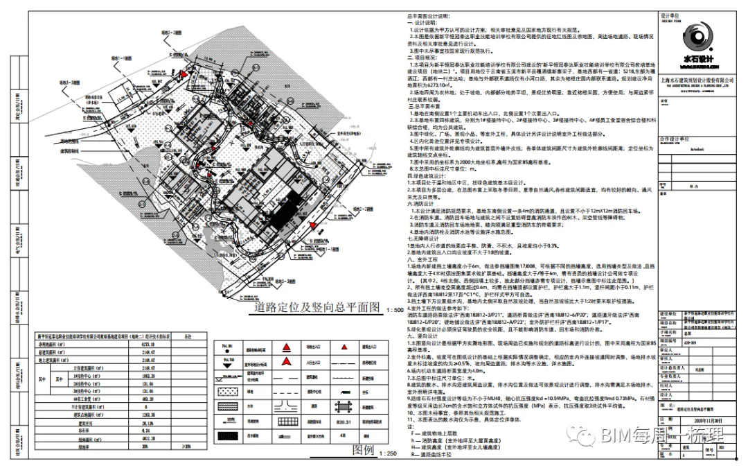
On November 8th, 2020, we submitted a version including the overall layout plan, road positioning, vertical layout, and a schematic of the fire road and firefighting site layout.
2. Distance between all buildings and the land red line: Marked as required.
3. Spacing between buildings: Marked as required.
4. Outdoor fire hydrants: Please refer to the central file location link shared with the water engineering team. The water team has provided a CAD version, which can be imported into Revit after submission.
5. Several site areas lack elevation data and need refinement. The landscaping sections require model detailing, elevation marking after refinement, and backfilling. Completion targeted for November 8th, 2020.
6. Green space backfilling and various road paving consolidation: The green areas need further detailing and filling after model refinement.
7. General Map Index Table: Completed on November 9th, 2020.
8. Legend: Completed on November 9th, 2020.
9. Building outline annotations (in meters): Annotations are partially completed and will be updated once the venue is fully developed.
10. Research and training building courtyard and roof: The existing contour representation is incorrect. Depth of view has been adjusted accordingly.
11. Dormitory building decorative roof: The roof outline was missing and has now been added.
12. Outdoor flooring method: Completed on November 8th, 2020.
13. Differentiation of motor vehicle and non-motor vehicle parking space fill styles: Completed on November 8th, 2020.
14. Xinping Technical Measures Specification (Word version): Requires the retreat of land use boundaries and expression of building control lines. Adjustments made as required.
15. Structural and landscape rubble retaining wall annotations: Positions of both structural and rubble retaining walls need to be clarified.
16. Non-motorized parking spaces: If parking space frame lines are not indicated, the area must be shown. Parking space widths have been indicated.
17. Research building elevated level: The extent of the elevated level needs to be expressed and has been adjusted accordingly.
18. Road elevation, outdoor site design elevation, and indoor elevation annotations: Differentiated by annotation family styles. Completed on November 8th, 2020.
19. Wind Rose: Imported directly from CAD into the schematic or drawn in Revit. Completed on November 8th, 2020.
20. Marking of road red lines, land red lines, and building control lines: Names have already been marked.
21. Refer to the design instructions for other projects organized by the company: Completed on November 9th, 2020.
22. Organize relevant outdoor engineering practices based on Southwest Collection and confirm with me or XCMG after selection: Completed on November 8th, 2020.
23. Provide at least two site profiles to indicate site orientation: Completed on November 9th, 2020.
24. Many slope angles and directions within the land use red line are missing and need supplementation: Supplemented as required.
25. Due to poor export quality of DWG files from Revit, it is recommended to print PDFs with frames first to check drawing print quality.
Article reprinted from the official account: BIM combs every Monday.


Must log in before commenting!
Sign Up