This article references the 2018 publication Towards Digitalization of Building Operations with BIM from the Berlin Institute of Technology in Germany.
Background Overview
In the first two articles, we discussed topics such as Building Information Modeling for the Whole Life Cycle Operation Stage of Buildings, the BIM-FM Research Project, workflow analysis for digital data collection at project completion, and methods for data acquisition and utilization. This article focuses on the BIM-FM Interconnected Building Data Platform and Future Directions.
04 BIM-FM Interconnected Building Data Platform and Future Directions
As illustrated in Figure 7, the concept of the BIM-FM Linked Building Data Platform (BIM-FM LBDP) integrates existing information sources. Acting as middleware software, BIM-FM LBDP enables facility managers to access information on demand through ad hoc queries or predefined rules. Initially, this can be achieved using a simple web browser.
The core idea behind BIM-FM LBDP is to simultaneously query all connected information sources (shown on the left side of the figure), allowing users to make a single request and receive consolidated responses from multiple data sources. For example, when retrieving information about a fire extinguisher, BIM-FM LBDP gathers data from the CAFM database—including maintenance records like the last inspection date—and from linked building models. Objects within the building model are represented as parameterized entities, including their positions and geometric details, enabling the CAFM entries to be kept to a minimum.
To leverage the scanning dataset described in Chapter 3.3.2, all line segments of the point cloud are also integrated as information sources. Since markers can be attached to point cloud segments and stored, users can visually locate specific areas containing search terms within the point cloud. Precise measurements can be performed directly on the point cloud without additional setup in the building model. This approach aims to reduce the need for fully detailed building models, relying instead on “lightweight” BIM objects with fewer details.
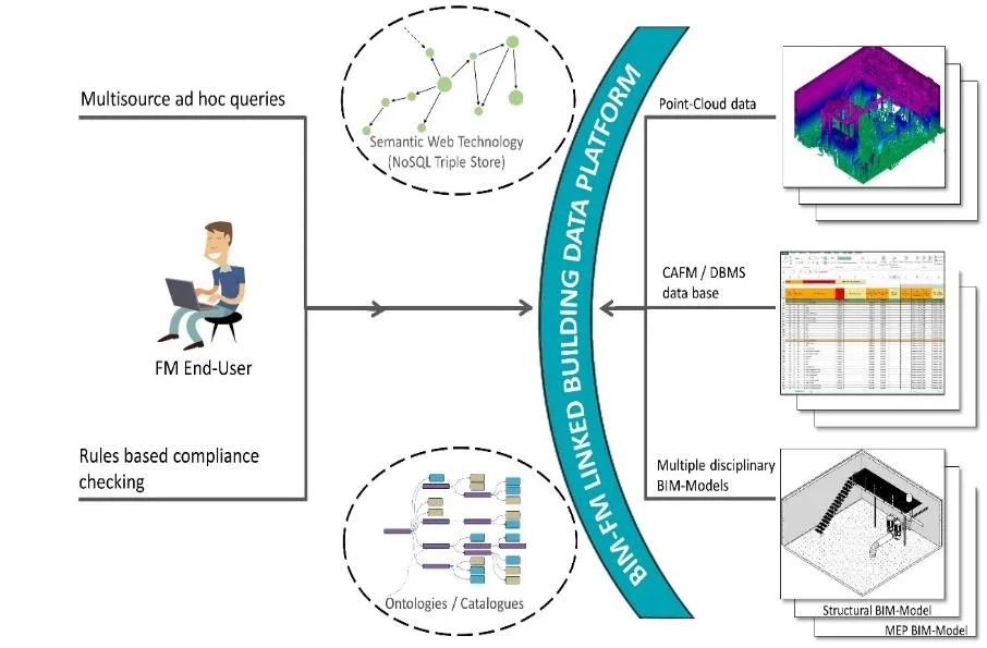
Figure 7: BIM-FM Linked Building Data Platform
This multi-source integration approach requires common directory definitions and ontologies at the semantic level to establish linked data. Within the project, techniques were evaluated to export several connected data sources to semantic web endpoints. For the first time, it is feasible to export building models based on IFC standards into a semantic three-layer storage system.
05 Conclusion
Two prototype digital building models were developed for existing buildings in Berlin, applying methods from the BIM-FM research project. One model was created from the perspective of FM service providers (Verbändehaus in Berlin Mitte), and the other from the perspective of FM and owners (St. Hedwig Hospital, also in Berlin Mitte). Additional on-site trials took place at HTW Berlin’s Wilhelminenhof campus, using ground-based 3D laser scanning combined with drone photogrammetry and smartphone measurements based on Google Tango technology. The collected data underwent post-processing steps, including registration, cleaning, segmentation, and semantic parametric modeling. Finally, all information was uploaded to a public data environment implemented with an open-source database application, linking the data to a commercial CAFM system.
Based on the field test results and feedback from FM organizations, a universal workflow was developed that offers three methods to utilize captured data: scan to BIM, scan to CAFM, and scan to dataset. These combined methods enable on-demand modeling throughout a building’s service life, significantly reducing the initial effort required to establish digital building models.
The results from the three digital acquisition techniques are promising. Specifically, 3D laser scanning is highly effective for quickly capturing large, visible areas and surfaces. Because point cloud data can integrate multiple capture methods, combining drone measurement technology with 3D laser scanning is recommended. This combination provides point cloud data for outdoor areas not visible through laser scanning alone, such as inaccessible roof structures or highly detailed elevated elements (see Figure 4). For critical detailed elements that are difficult to capture with laser scanning or drones—such as indoor protection elements—alternative methods like those shown in Figure 3 are advisable. For example, at St. Hedwig Hospital, integrating point cloud data from 3D laser scanning and Google Tango technology offers a comprehensive solution.
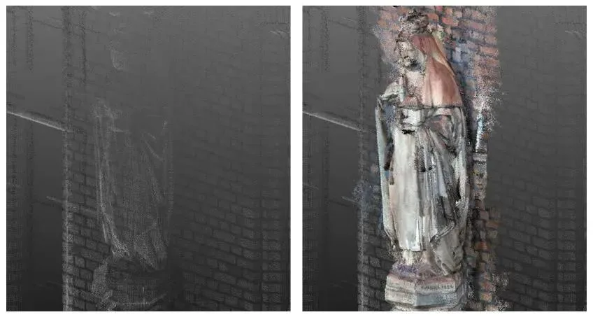
Figure 3: St. Hedwig Hospital example showing integration of point cloud data from different measurement techniques (left: 3D laser scanning; right: 3D laser scanning combined with Google Tango technology)
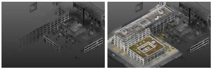
Figure 4: Wilhelminenhof HTW Park pilot test demonstrating integration of point cloud data from various measurement technologies (left: 3D laser scanning; right: 3D laser scanning combined with drone measurement)
Regarding raw data processing, existing software can automate many labor-intensive tasks and scale effectively. However, manual efforts remain necessary for modeling and post-processing scanned data. It is unrealistic to expect all FM completion data for existing buildings to be converted into digital building models immediately. Therefore, future data environments must manage parameterized IFC models, marker-rich point cloud data, and alphanumeric CAFM data. Employing powerful semantic query engines to access this heterogeneous data will be crucial to successfully integrating BIM methods into modern FM operations.


Must log in before commenting!
Sign Up