Traditionally, in the landscaping industry, communication between designers, constructors, and owners relied heavily on two-dimensional CAD drawings and text documents. However, these 2D files often made it difficult for owners to fully grasp the three-dimensional layout of a design. This limitation led to misunderstandings and miscommunications during design discussions, causing delays and inefficiencies.
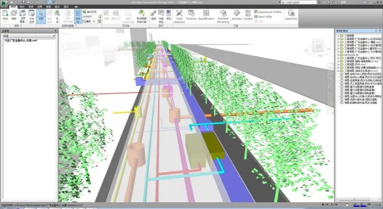
BIM technology addresses these challenges by enabling virtual walkthroughs through software such as Revit, Navisworks, Lumion, and other visualization tools. These platforms allow users to intuitively explore the layout and overall impact of structures, architecture, MEP (mechanical, electrical, and plumbing) systems, and landscape architecture within a project. Users can interact with the 3D model using simple controls like a mouse, which facilitates effective planning of outdoor landscape elements, greenery, and other components.
Moreover, BIM helps identify design issues early, allowing timely adjustments and preventing costly rework. For example, it enables evaluation of building appearance, layout feasibility, and whether garden landscapes meet design requirements. It also supports the creation of virtual samples, reducing the need for physical mock-ups and helping owners and contractors control costs and materials more efficiently. As shown in Figure 1:
The landscape design significantly influences the overall aesthetics of a construction project. Traditionally, landscape designers expressed their vision through 2D CAD drawings, which often made it challenging for builders to fully understand the design intent. This disconnect sometimes led to construction delays or deviations from the original plan.
Currently, many landscape projects struggle with terrain excavation and grading that do not meet design specifications. Terrain is often constructed with uneven elevations, making it difficult for designers to realize their plans accurately on-site. This issue is not entirely the fault of the construction team; rather, it stems from the limitations of 2D CAD drawings. These drawings often overlook the actual topography of the site, requiring builders to rely on on-site measurements and adjustments. Consequently, designers and constructors must frequently revise terrain plans, resulting in wasted time and suboptimal outcomes.
BIM technology offers a solution by using imported CAD drawings as the modeling basis and converting them into 3D parametric models. This approach provides a solid foundation for visualizing design schemes in three dimensions. BIM enables detailed refinement of project designs during both the design and construction phases. It integrates parametric data from all disciplines involved in the project, including terrain and site planning data from owners and government agencies, as well as information about the surrounding environment and existing buildings.
By consolidating this data, BIM creates a comprehensive base for design work. Unlike flat, unremarkable 2D CAD terrain, the 3D terrain models generated with BIM are realistic and actionable. This capability makes BIM a powerful tool for guiding construction accurately.
For example, Revit can transform 2D terrain elevations into a 3D parametric model, allowing easy adjustments to reflect changes in elevation and optimize design solutions. During design presentations, BIM models can replace traditional PPT slides or CAD prints. These models support 4D simulations and virtual walkthroughs, providing multiple perspectives on terrain design and elevating the design process from static 2D visuals to dynamic, information-rich 3D presentations.
Landscape visualization is a key application of digital technology in landscape architecture. It enhances communication with owners and stakeholders by providing clear, immersive presentations, which can improve the chances of winning bids and gaining project approval.


Must log in before commenting!
Sign Up