Road engineering projects differ significantly from single building projects in terms of construction site layout. They are typically distributed along a linear strip and are closely connected to spatial geographic information, including geology, hydrology, and topography along the route. Variations and similarities in these spatial geographic factors can lead to substantial adjustments in design elements such as route alignment, bridge locations, and bridge types.
In the construction industry, Building Information Modeling (BIM) is primarily applied to building modeling. However, for road engineering surveys and designs, establishing 3D geological models and integrating them with disciplines such as roads, bridges, and tunnels using BIM technology is crucial. A digital 3D geological model provides a virtual, realistic representation of the geological environment. It clearly and intuitively displays geological layering, helping designers accurately analyze site-specific geological conditions, develop reasonable design plans, and facilitate communication between design and construction teams. This approach supports the formulation of scientific construction plans and helps reduce engineering risks.
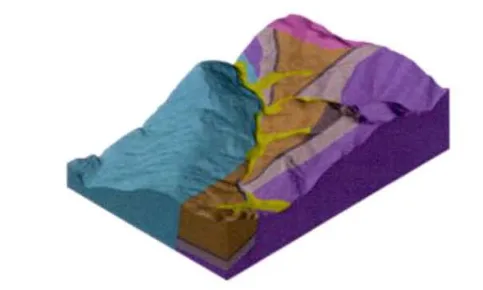
Figure 1: Three-dimensional geological model
Using BIM’s unified collaboration platform, all measurement data—including terrain, buildings, ditches, pipelines, poles, water systems, and more—are integrated into the model as 3D objects, creating a virtual construction environment for road projects. Topographic survey data allows for the creation of terrain surfaces that can be represented through various forms such as triangulation or contour lines. This enables detailed analyses of elevation, slope, water bodies, and flow directions on the terrain.
With advances in computer and information technology, measurement techniques continue to improve. The adoption of 3D point cloud data, photogrammetry, satellite positioning, and imaging technologies has fully ushered measurement into the era of 3D digital simulation.


Must log in before commenting!
Sign Up