Terrain Surface refers to a three-dimensional geometric representation of the land within a specific area. It forms the foundation for using Civil3D in 3D road design and serves as a crucial data source for tasks such as route planning, profile design, engineering calculations, and safety analysis. Thanks to Civil3D’s parameter-driven and constraint-linked workflow, any modifications made to the terrain surface automatically update all associated objects, including roads, slopes, and profiles.
Terrain Source Data
Civil3D supports a variety of source data formats to create terrain surfaces, including point files, DWG topographic maps, DEM data, GIS data, point clouds, and even Google Earth, as illustrated in Figure 1. Additionally, measurement objects like trees, rivers, and buildings can be integrated into the terrain surface to accurately reflect the real terrain and landform features of the project area. All measurement data is stored within the Civil3D database, ensuring that when this data changes, the linked terrain surface updates accordingly. This highlights how BIM technology effectively manages complex terrain data and builds highly accurate terrain surface models, providing a detailed design foundation for subsequent project stages.
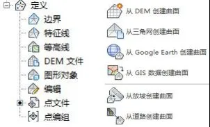
Figure 1: Source Data Formats for Terrain Surface Creation
Constructing 3D Terrain Surfaces
Civil3D offers two primary methods for building 3D terrain surfaces: triangular mesh surfaces and grid surfaces, as shown in Figure 2. A triangular mesh surface is created through Delaunay triangulation of discrete spatial points. Civil3D automatically identifies the closest points in space to form triangular mesh lines, defining triangles. The elevation of any point on this surface is interpolated based on the elevations of the triangle’s vertices. Conversely, a grid surface consists of points arranged in a uniform grid pattern. The grid’s spacing and orientation can be manually adjusted to meet the desired accuracy of the surface.
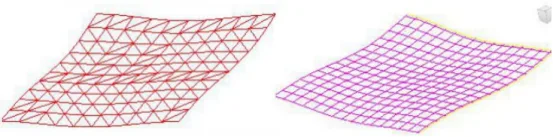
(a) Triangular mesh terrain surface (b) Grid terrain surface
Figure 2: Terrain Surface Styles in BIM
Generally, triangular mesh surfaces are preferred when modeling complex and variable terrain using irregularly spaced sampling points or when analyzing localized terrain within large datasets like point clouds. Although this approach involves complex algorithms, larger data formats, and higher hardware demands, it offers precise surface representation. On the other hand, grid surfaces are suitable for uniformly distributed terrain sampling data, benefiting from simpler algorithms and faster loading times.
Terrain Surface Analysis
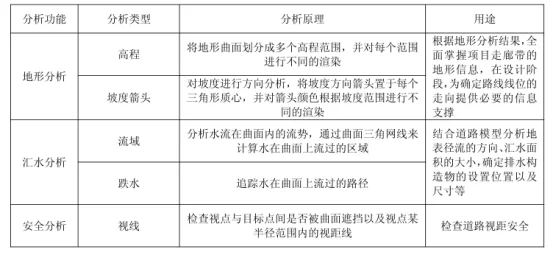
BIM-based road modeling platforms offer a wide range of analytical and calculation tools. Civil3D includes diverse terrain surface analysis functions, with the corresponding principles and features summarized in the table below.


Must log in before commenting!
Sign Up